Table of Contents
- What Is an Interactive Tower Map?
- How Does an Interactive Tower Map Work?
- Interactive Tower Map vs Static Floor Plan
- Why Do Off-Plan Developers Use Interactive Tower Maps?
- What Should an Interactive Tower Map Include?
- How Do You Add One to Your Website?
- Frequently Asked Questions
What Is an Interactive Tower Map?
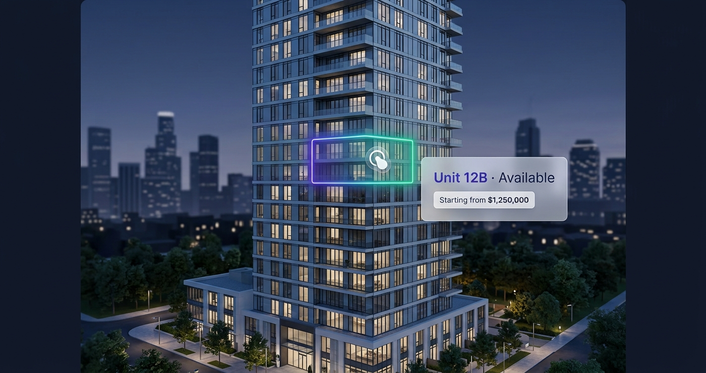
An interactive tower map is a clickable version of your building. Instead of showing buyers a flat rendering of your tower and a separate PDF of floor plans, you show them the actual building image — and let them click any unit to see its price, availability, floor plan, view, and gallery, right on your website.
You’ll also see the same tool called an interactive floor plan, an interactive site plan, or a building visualizer — different names for one idea: a clickable building that shows live unit availability instead of a static image.
Think of it as the difference between a printed map and Google Maps. The printed map shows you everything at once but you can’t interact with it. Google Maps lets you zoom, click, and explore. An interactive tower map does the same thing for a multi-storey development: it turns a static sales image into a living tool that answers a buyer’s questions the moment they have them.
For real estate developers selling off-plan — before the building is complete — this matters enormously, because the buyer is committing to a unit they can’t physically walk through. The clearer you make each unit, the more confident they are to reserve. It’s a small change with an outsized effect: industry surveys consistently find buyers are far more likely to engage a listing they can explore themselves — around 8 in 10, in some studies — than one that hides the plan behind a PDF.
How Does an Interactive Tower Map Work?
An interactive tower map is built in three layers on top of the tower elevation image you already own:
1. The image layer
Your existing 2D building rendering serves as the base — the same image already in your brochure. Nothing new to design.
2. The overlay layer
Every unit’s boundary is mapped as a clickable SVG shape directly on the image. These overlays scale mathematically, so they stay pixel-perfect on a phone, tablet, or desktop — no misaligned boxes.
3. The data layer
Each unit connects to its own information:
| Data point | Example |
|---|---|
| Unit number | 12B |
| Floor | 12th |
| Type | 3-bed maisonette |
| Area | 190 m² |
| View | Ocean / harbour |
| Price | Shown or on request |
| Status | Available / Reserved / Sold |
| Gallery | Interior photos + floor plan |
When a buyer hovers or taps a unit, a tooltip appears with the key facts. When they click, a full panel opens with the gallery and an inquiry button. When they inquire, your sales team receives a lead that already names the exact unit, floor, and price point.
Interactive Tower Map vs Static Floor Plan
| Static image / PDF | Interactive tower map | |
|---|---|---|
| See a unit’s price | ❌ “Contact for pricing” | ✅ On hover / click |
| Check availability | ❌ Call or email to ask | ✅ Live status per unit |
| Explore on mobile | ⚠️ Pinch-zoom a PDF | ✅ Tap-optimised |
| Remote / diaspora buyers | ❌ Confusing, high-friction | ✅ Self-serve, 24/7 |
| Lead quality | ❌ “I’m interested” | ✅ Unit-specific, qualified |
| Sales-team workload | 🔴 Repetitive questions | 🟢 Automated answers |
The core difference: a static floor plan makes the buyer do the work and then wait for a sales rep to fill in the gaps. Every gap is a chance to lose them. An interactive tower map closes those gaps instantly. We break the comparison down further in interactive floor plans for real estate developers.
Why Do Off-Plan Developers Use Interactive Tower Maps?
Three reasons come up again and again:
- Buyers can’t visit the building. For off-plan and diaspora buyers, the website is the show unit. A clickable tower lets someone abroad explore units at midnight and reserve before they close the tab.
- Qualified leads. An inquiry from a specific unit tells your team the buyer’s floor, budget, and preference before the first call — so they’re closing a warm lead, not starting cold.
- Competitive edge. When a buyer compares three developments and only one lets them explore units interactively, that one feels more transparent and more premium. We cover the sales impact in how real estate developers can increase pre-sales with technology.
What Should an Interactive Tower Map Include?
Not all tower maps are equal. A production-grade one should include:
- Per-unit detail — price, area, beds/baths, view orientation, gallery, floor plan
- Live availability — Available / Reserved / Sold, updated in real time
- Smart filters — by floor, unit type, bedrooms, price, or “available only”
- One-tap inquiry — a form plus direct call / WhatsApp buttons
- A management dashboard — so your sales team updates pricing and availability themselves, no developer needed
- A lightweight, mobile-first build — fast on real-world connections, so buyers don’t bounce
- On-brand design — your colours, your currency, optionally white-labelled
How Do You Add One to Your Website?
Modern interactive tower maps are delivered as an embeddable widget — a single line of code that drops into your existing website on any platform (WordPress, Webflow, or custom). No rebuild, no migration.
At FoudaTech, the process is: you send your tower image and unit data, the map is custom-built and mapped to your building, and you receive an embed snippet plus a dashboard. It’s delivered as a managed service — hosting, updates, and support included — so it keeps working as your development sells out.
See a live interactive tower map → or request a free preview of your building.
Frequently Asked Questions
Is an interactive tower map the same as a 3D model?
No. A 3D model is a heavy, slow walkthrough. An interactive tower map is a lightweight overlay on your existing 2D image — it loads fast on mobile and focuses on the one thing that drives sales: exploring and inquiring on specific units.
Does it work for a single tower or multiple towers?
Both. A single-tower map covers one building; multi-tower developments get a map per tower with shared navigation so buyers can compare units across the whole project.
Can buyers use it on their phones?
Yes. The overlays scale to any screen, and hover becomes tap on mobile — which matters, because most property browsing happens on a phone.
Do we need to rebuild our website?
No. It’s delivered as an embeddable widget — a single script tag that drops into your current site with no redesign.
Can our sales team update prices and availability?
Yes. A management dashboard lets your team toggle unit status and edit pricing in real time, with no developer involvement.
How much does an interactive tower map cost?
Pricing is a one-time setup fee to build your custom map plus an annual subscription for hosting, the dashboard, support, and edits. Contact us for an estimate based on your building.
Is an interactive tower map the same as an interactive floor plan or site plan?
Effectively, yes — they’re different names for the same clickable-building idea. An interactive floor plan usually refers to a single floor, an interactive site plan to a whole development or masterplan, and an interactive tower map to a multi-storey building. FoudaTech builds all three from your existing renders, with live unit availability.